If this isn't the highway to heaven, it sure bears a strong likeness. The road winds upward through sagebrush and pinon pine, then mountain mahogany, quaking aspen and limber pine. The lake is in a glacial cirque in the East Humboldt, a young, craggy and visually spectacular range. Its scarps and spires have a character that changes with the season and the light, like the wizened face of a Basque bartender.
We also have the following visitor guides in Nevada. Click on any additional guides you would like to receive.
Lake Havasu City Western Arizona
Lake Havasu City
Western ArizonaWelcome to Lake Havasu City…where you can Play Like You Mean It®! Located on the Arizona shoreline of Lake Havasu, Lake Havasu City is a destination for boaters, water sport enthusiasts, hikers, nature lovers, car enthusiasts and history buffs. It attracts 775,000 visitors a year with its calm waters, beautiful beaches and desert weather with more than 300 sunny days a year. Request this Free Visitor GuideRequested!You're all set! Request a few more Visitor Guides, or complete the form below to receive your guides by mail.
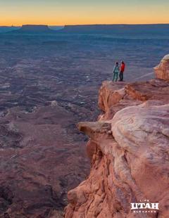
Utah - Life Elevated Statewide
Utah - Life Elevated
StatewideWith five national parks and more than 40 state parks, Utah offers a wealth of outdoor activities for families & adventurers alike. Order your free Travel Guide today. Request this Free Visitor GuideRequested!You're all set! Request a few more Visitor Guides, or complete the form below to receive your guides by mail.
Specialty Guides
Maverick Helicopters Nevada, Arizona, Hawaii, and California
Maverick Helicopters
Nevada, Arizona, Hawaii, and CaliforniaUnforgettable Tours Offered in Nevada, Arizona, Hawaii, and California. Request this Free Visitor GuideRequested!You're all set! Request a few more Visitor Guides, or complete the form below to receive your guides by mail.
We also have visitor guides available in states highlighted in blue below. Click on any state to see what's available.
Alaska
Arizona
California
Canada
Colorado
Hawaii
Idaho
Louisiana
Michigan
Montana
Nevada
New Mexico
Ohio
Oregon
Texas
Utah
Washington
Wyoming
Switch to Mobile Browser Mode
We offer a compact version of Go-Nevada for mobile users, allowing you to access just the information you need on the road. Of course, you can still use the full version of Go-Nevada on your mobile device just as you can on your desktop.